
Return to the list
Circuit PR "Le Bois de Chemasson"
13 kilometers long hiking trail around Saint-Paul-le-Gaultier and Saint-Léonard-des-Bois.

Address :
72130 SAINT-PAUL-LE-GAULTIER
FRANCE
72130 SAINT-PAUL-LE-GAULTIER
FRANCE
Contact: Circuit PR "Le Bois de Chemasson"
For further information, please contact the service provider directly by completing the form below
Presentation of: Circuit PR "Le Bois de Chemasson"
13 kilometers loop from Saint-Paul-le-Gaultier
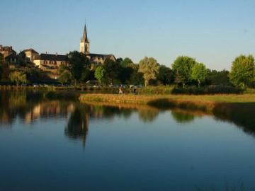
Starting from the fishing pond in Saint-Paul-le-Gaultier
Difficulty level : medium
Signs color : yellow
Starting from the fishing pond in Saint-Paul-le-Gaultier
Difficulty level : medium
Signs color : yellow
Type of routes/Nature of route
Promenade et Randonnée (PR) footpath
Departure town
SAINT-PAUL-LE-GAULTIER
Arrival town
SAINT-PAUL-LE-GAULTIER
Distance
13 Km
Means of transport
Walking, difficulty level: Average, duration: 3h30min
Colour of tag
jaune
Type of road surfacing
70% on dirt road
30% on right-of-way


