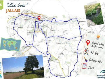
Randonnée "Les bois"

The walking route runs through the commune of Jallais.

Discover this 12km walking trail in the commune of Jallais.

Departure point: Place de la Mairie, Jallais.

Contact

Location icon

49600 BEAUPREAU-EN-MAUGES
FRANCE
Contact

Practical information

Departure town

JALLAIS

Arrival town

JALLAIS

Distance

12 Km

Means of transport

Walking, duration: 3h

Colour of tag

Bleu

Access map, location

Road (national / local) : 0 km

Contact Randonnée "Les bois"

For further information, please contact the service provider directly by completing the form below

Further information to help you get around
CAPTCHA

The information you provide is for the exclusive use of the Pays de la Loire Region: we undertake not to pass it on to third parties.

Other: On foot

Course d'orientation à Morannes
Location icon
Morannes Sur Sarthe-daumeray
Réservable en ligne
jessy thielleux
LES PAPILLONS DE L'ORMOIS
Location icon
Montoir-de-bretagne
©LAISNE
La pierre aux fées
Location icon
Le Champ-saint-pere
OT DVGL
Office de tourisme Châteaubriant-Derval
Le tour des villages
Location icon
Erdre-en-anjou
©Office de Tourisme de l'Anjou bleu
OTVN
LES GRANDES ÎSLES
Location icon
Saint-joachim
CAP Atlantique
© JC Druais - Mayenne Tourisme
Le vœu de Saint-Quentin
Location icon
Saint-maixent
David PIOLE